
Looking for Booty
We’ve been doing a lot of exploring on this island, looking for something, or nothing at all, just walking and looking. Treasure? Sure, there is treasure here, I have no doubt about that. You can’t have had all those pirates living here for all those decades all those centuries ago, and not have some buried treasure still stashed away somewhere.
Utila and the Bay Islands have a storied history from long before Christopher Columbus, but in the Age of Discovery it got particularly interesting. That was the time when ole Chris, Amerigo Vespucci, Juan Ponce de León, the Pinzón brothers, and countless others explored the new hemisphere, colonizing it for trade and power. Columbus himself was here in Guanaja, two islands to the east. All this resulted in discoveries of great wealth in this part of the world in the form of gold and silver, as well as the glorious civilizations of the Maya and Aztecs. These riches were not found on the small islands but in the heart of the Central American mainland. Of course, once wealth was known, wealth had to be plundered. The bay islands were at times plundered for slaves by the Spanish, and at other times were home to literally thousands of pirates plundering ships attempting the Caribbean crossing. Divers in Utila today still search for Captain Henry Morgan’s lost booty from a raid on Panama in 1671.
Our searches have focused on the beaches (don’t look at us that way, we like to look where the light is good!), but we also get around other parts of the island. It’s no more than about 3 miles across (north to south) at its widest points, and about half that in most places, so we can hike all the way across and back in an afternoon. The first one we went to was a civilized little beach on the southeast “corner” of the island called Bando, a private beach that asks you to pay $2 each so they can afford to maintain it (mostly, rake the sand clean). It’s a relaxing place to sit and read, go for a swim and just watch the ships pass through the channel (ferries and cargo ships from Roatan & La Ceiba). We’ve gone back and forth on it, from “I’m not paying to go to the damn beach” to “Bando is kind of nice, and those chairs under the palm trees are so comfortable, and…”. The bar at this beach is excellent as well, and very possibly has buried treasure near it somewhere. That’s why we keep going back!
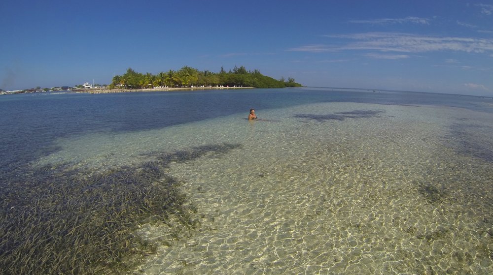 Searching for treasure on the sandbar at Bando Beach
  Salud!
The main alternative to Bando (I suppose Bando is really the alternative) is the public beach (Officially Chepes Beach) which is nice in its own right. It’s near the west edge of the bay and has the semi-famous Relapse Bar overlooking it from the side. Across the street from the sand are several small restaurant/bars where you can get baleadas and beers. We found one tiny family-run place where we get to work on our Spanish and buy limonada and cheap beer to take down to the water. This place is so small that they couldn’t change a 500L note for me one day. That’s the equivalent of a $20 bill they couldn’t change, to give you an idea of my surprise. I offered to buy 2 beers, but she just said that I could pay her later. Those are the kind of people that make this place special. She knew me and she trusted me, after having stopped by maybe 3 or 4 other times in the past 2 months. And nobody cares if you walk around with a beer on the beach so that’s what we do, while we look for treasure of course.
Out of town, we’ve done a lot of exploring in places where we were practically lost. It was only later when we would dig up details on the maps to figure out where we’d been. In one case, we went around the point on the southeast edge of the rock and up the coast there. We passed Old Airport Beach which is very rocky, not much to see there except dive boats offshore. We later dug up a years old map and found that the road we were walking down was where the airport runway used to be. I have to guess it was just a hard packed coral base the planes would land on because that’s all the road is today. Carrying on, we saw a line of big beautiful beachfront homes that stand tall enough that we can see them clearly from our deck back on the hill near town, a couple of miles away. These homes are mostly part-time residences and are looked down upon by many locals as not really being part of the community. I don’t begrudge anyone their success, but we are proud to be a small part of the town, even if it is only for a few months.
 We snorkeled over to that tiny island
Between a couple of these big houses we spotted a walkway to the water that was very inviting. My guess is that this was required by some local ordinance so the foreigners don’t get to cut off what would otherwise be a public access to the water. We went down the path and found a nice place for snorkeling, although there were lots of sea urchins. We managed to avoid them and enjoyed snorkeling over to the little island a hundred yards across the gap. It was a wonderful, quiet little island, nothing to do there but sit on the edge of the water and soak up the sun. No booty was found, but honestly, it was too relaxing to look.
 Somebody’s plans were foiled
One day on the advice of a young “local Canadian” guy, we walked past all the big houses and found a whole new beach in an area generally known as Iron Shore. There are palm trees placed here in permanent planters made of stacked stones, giving the appearance that somebody planned to develop the property and build a bunch of homes. From the look of it, their plans fell through several years back. I believe the name Iron Shore is based on the fact that the beach in this area is mostly dark brown rock that looks like rusted iron. With the crashing waves, it didn’t look swimmable to us that day, maybe not ever. It also wasn’t very appealing – this beach had a LOT of plastic trash washed up on it and because it is so far from anything, there’s nobody around to do much about it. It would be a full time job for someone to keep the beach clean of this stuff, depending on how far down the shore you wanted to cover, but if you had a neighborhood association to pay for it, I’m sure it could be done. On the walk back we picked up the unmistakable aroma of pot plants in the jungle (coming from Colorado, we know this smell). We got out of there – I didn’t want some guy thinking we were renegade harvesters trying to get his crop!
 The Iron Shore
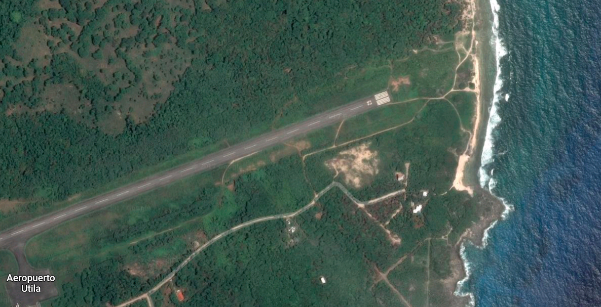
Another day we were hiking/wandering/walking, in flip-flops as always, trying to take a different route that would eventually end up near the opposite end of Iron Shore. We walked down by the airport and continued down the road as it went to dirt. When we got to a fork in the road, we took it! It had been raining buckets every night at that time, and the dirt roads we were walking consisted of a hundred feet of hard pack, followed by a large puddle of unknown depth and creatures. This was repeated for miles! In each case, on one side was jungle and on the other was barbed wire. So we’d step rock to rock, or tip-toe the edges while holding onto vines, twigs, or wire to keep from falling butt first into the puddles. After a couple miles we got to a point where it was just endless puddles and decided this just wasn’t the day to take this route. So we went back to the fork and took the other direction, walking down a slightly less muddy path toward a different beach. As the road turned away from the jungle toward the lower brush it dried up a bit and we knew we were getting close to the beach. We saw a short side road and wanted to check it out. Well, out there in the middle of nowhere, we ended up standing on the (new) airport runway, which is paved and much longer than the old one. Yep, there we were. We probably violated some Honduran federal law, but all we did was take a dirt path off the other dirt path we were walking down and hello, we were standing at the end of the runway. I swear, we’re innocent, don’t shoot!
 I knew I shoulda taken that left turn at Albuquerque!
 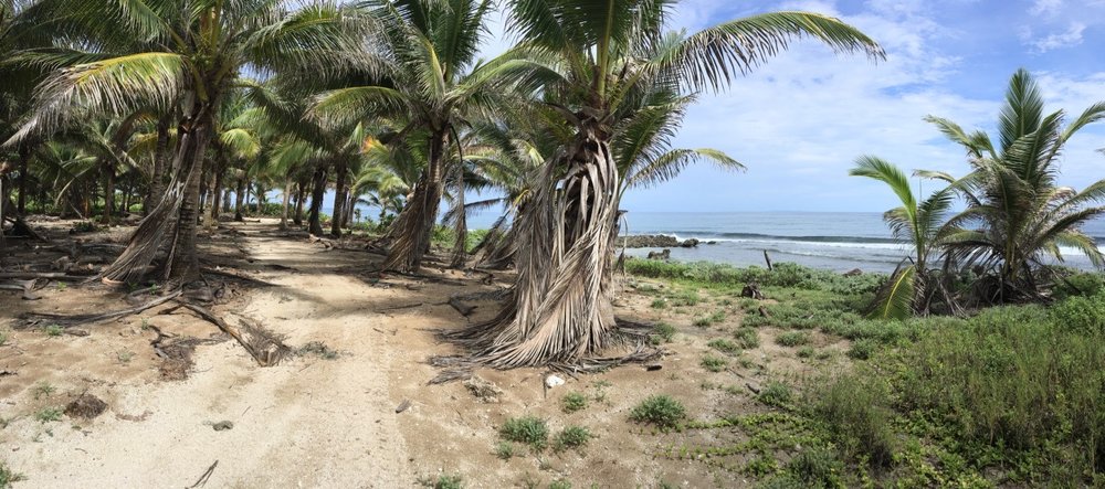 Past the airport runway, this is what we found: no people, just the sound of the waves
We got a free ride one day across the island from south to north over to Pumpkin Hill Beach. The catch was that we were part of a volunteer crew of young scuba divers and other tourists, doing a beach cleanup. I proudly held the title of oldest dude in sight (by a long shot) at this event! It was hard work but really rewarding for all of us. Within a couple of hours about twenty of us made a very noticeable improvement to this beach, and gave the baby sea turtles better access to the water when they hatch. We want to go back to this part of the island on our own before we leave, it’s got beautiful views and is very quiet out there.
 Stay away from my booty!
  We are in that blue “Yumbo”, near the front, packed in like sardines. Great crew of volunteers!
I should mention that most of the sand around Utila is not the soft sand of the Bahamas, and certainly not the pure white soft sugar we found in Siesta Key, FL. It is larger grained and a little rougher on the feet, nice to look at, and nice but not heavenly to walk on. And many of the beaches are more rock than sand, often with a load of driftwood in the form of large tree branches and logs. The beaches also tend to be “short”, only a few yards of sand deep; I haven’t seen much in the way of tidal action that exposes more or less shoreline. They look great in pictures though!
So the beaches are somewhat limited, but the snorkeling is better, and better still when it hasn’t rained for a couple of days. The runoff from heavy rains puts a haze in the water esp. close to shore. But we have had several very nice swims in a couple of places, Coral View and Neptune’s. Coral View offers lodging about a mile west of the public beach on a thin strip of land between the sea and the lagoon. On the lagoon side they have a boat dock with rentals and do scuba and other trips by boat. On the sea (south) side, they have a peaceful dock out into the water with a small bar that is open sometimes, and closed other times. When it’s open, they ask that you either buy a drink or pay a small fee to use their dock. When it’s closed, you just go snorkeling. And they have really good snorkeling – we really like it even if we have to dodge the pesky sea urchins.
 Coral View dock on a day they were closed.
Neptune’s is farther west on the same side of the island and is accessed by picking up an hourly shuttle boat on the lagoon, near the Coral View dock. There is a fee of about $4 each but it is fully redeemable at the restaurant/bar at the beach. This just keeps people from taking a free ride on the boat, and crowding out the paying customers. The boat takes you a couple of miles down the lagoon, through some partially-developed waterfront property. It’s a very interesting area, very laid back, very casual looking houses, and many lots for sale. Then there’s the huge modern house of concrete, steel, and glass that looks exactly like a drug lord’s house from Miami Vice. When we puttered by it was complete with a well-dressed young stud on the upper deck talking on a cellphone. When you get to the other end, you walk toward the beach and the restaurant/bar with palm trees, lounge chairs, and a dock into the sea. It’s a nice day at the beach there, even if they do seem to have a special species of sand fly with extra large teeth.
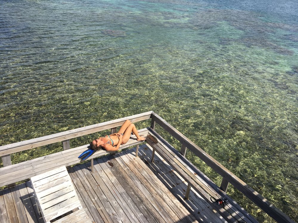
 Neptune’s pier – snorkeling is off the end, and scuba dive boats are moored just a bit deeper
Many times our snorkel spot choices have been validated by the arrival of a scuba boat. They offload their divers a hundred feet or so away from us. Then, while we enjoy the relative shallows, they of course go into the depths down the coral walls. This is the reason we purchased a bright green “Diver Down” float, just to make sure we don’t get run over. I suspect the scuba people have an advantage in looking for the Capt. Morgan stash, but we try anyway!
At the far western tip of the island are the Utila Cays, accessible only by boat. We took a tour boat out there one day with a half dozen others and saw the gorgeous sights of Water Cay. It’s an uninhabited island, a public park with lots of beautiful palm trees, snorkeling on the south side, swimming with white sand on the north, and with the other cays all around, just beautiful scenery! We had a great time even as we struggled getting out to deep enough water to snorkel. It was probably a hundred feet of stumbling in our fins trying to get to something more than knee deep. Next time we’ll literally try a different approach.
 Water Cay
We briefly enjoyed a relaxing swim before a storm blew in from the direction of Belize and changed all our plans. Deb and I curled up in a couple of hammocks made of rip-stop material, so they kept most of the water out. The wind was blowing hard too, but we did pretty well. Deb said we’d never make it on “Survivor”. While we were curled up one of the others had knocked down a coconut and cracked it open, exclaiming “Lunch is served” to the others. While they chowed on coconut, we shivered in our hammocks. Not our finest moment!
At some point, the boat captain said we should go, and we loaded up and went over to Suck Suck (aka Pigeon) Cay & Jewel Cay. These two small cays are connected by a bridge and are quite a sight. Almost 100% covered with houses and small businesses, these tiny chunks of coral are surrounded by boat docks and water (of course), but no beaches. We got something to eat and drink and walked the whole island pair in about 15 minutes. Friendly people there also, but no booty.
 Suck Suck (Pigeon) and Jewel Cays. Don’t ask me why it is called Suck Suck – no idea!
 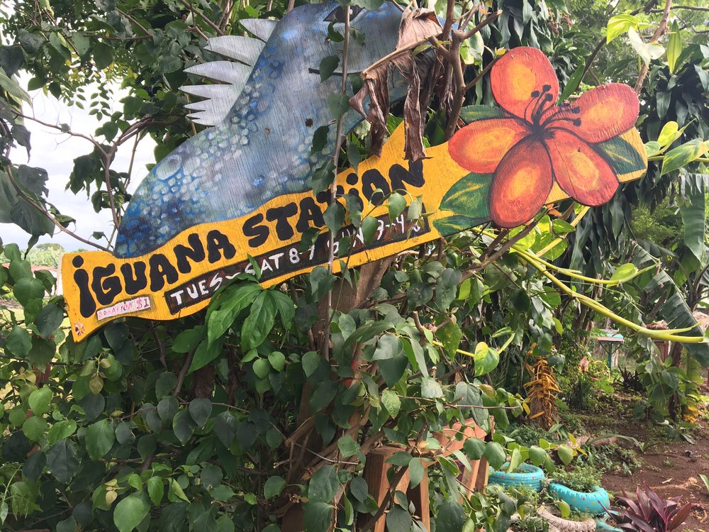 The home of the Swamper!
We’ve done our share of walking the neighborhoods here around Utila and discovered a couple of places who focus on conservation. One is just up the hill from us, the Bay Islands Conservation Association (BICA). They led the beach cleanup we participated in, and try to educate and help with conservation efforts around the island such as the #refusethestraw initiative. We also found the Iguana Station, which is focused on saving an endangered species of iguana, the so-called Swamper iguana. Living in the mangroves for centuries, this species is found only in Utila – no other place in the world. So mangrove protection is critical to the survival of the species. They also raise young ones at the station for a year, before releasing them into the wild. It’s a pretty great group if you ask me.
 Bay Islands Conservation Association building – Bienvenidos!
  RIP young lady
So, at our own pace, we have found time to do quite a bit of exploring, we haven’t found Captain Morgan’s booty yet, but we’ve found some treasures nonetheless. We even went to the local cemetery but they told us “treasure hunting” was no permitido. It was all in Spanish but I think they said something about “grave robbery”, and their shovels were bigger than ours so we left. We finally broke down and went right on over to Captain Morgan’s dive shop, they should know where to look, right? Speaking of Capt. Morgan and his pirate buddies, I like to think we’re pretty good at this treasure hunting thing, but we still haven’t found a big X in the sand anywhere. I guess those pirates were pretty good at hiding their booty after all!
 No luck here either!
TODAY’S SPECIAL – “Gettin’ Down in a Pirate Town” by Jesse Rice, because, why not?
Have you found any treasures in your travels? Shopping doesn’t count unless it’s at a used anything store like a thrift or antique store! Comment below!
Off the beaten path discovering lost beaches?! It’s good to be you!
It doesn’t suck, LOL!
Norm, I saw some booty in this post! Ha.Looks like you guys are having a blast.
?
I noticed that after I posted the picture, I swear! 🙂
We did get to go back to Pumpkin Hill Beach today. 2 1/2 mile walk each way. Down a dirt road through jungle. Our last trip there was on the back of a 4 wheeler there, and the little truck shown in the post back. So we got to enjoy the walk this time. We were able to explore parts of the beach that we hadn’t seen. Around a curve, was a very nice peaceful and beautiful cove. It rained the whole walk home, but there is something beautiful and calming about a walk in warm tropical rain. I may have enjoyed the walk home more than the walk there.
In Telluride up at the Tom Boy mine while stuck for the afternoon ( that’s another story ) we dug around and found three unbroken old medicine bottles ….treasure to us
Excellent! I love stuff like that. You just have to imagine the people who made it, bought it, used the medicine.